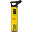
The Leica DSX Utility Detection System finds the location and orientation of utility lines beneath the ground. The DSX is very beneficial, and in some cases necessary, in construction, utility repair, and maintenance applications. It also helps heavy equipment operators by providing a visualization of the utilities, generating a 3D map, and having a reliable stake out before undergoing digging procedures.
Ease of Use: Leica DSX detection system ensures a smooth and accurate underground utility detection with the help of its durable hardware device, the Utility Detection Radar (GPR). It also features the DXplore, which is an intuitive, onboard software interface, allowing a complete scan, detection, and mapping in just a few steps. This easy-to-use device has an overall compact and rugged structure, making it reliable to use in narrow areas, and under difficult conditions.
Quick and Reliable Detection: The system is able to detect all types of underground utilities in high resolution for assuring reliable avoidance zones, while a set of smart algorithms verify the detection results. A complete site map of all the detected utility lines can be generated within minutes to provide a higher degree of awareness to the surveyor. The results and records can be exported in CAD and BIM-read formats for further use.
DSX has a number of operating modes for different types of scans. The B-Scan view helps in verifying ground conditions, identifying and marking ground anomalies, facilitating data interpretation and adding an additional layer of information.
Integrated Solution: DSX comes with a complete workflow, from data acquisition to excavation, ensuring effective and accurate experience. All the scans and detection results boast a survey-grade accuracy. For greater integrability, the generated maps are compatible with all coordinate reference systems.
Product Options
The Leica DSX Utility Detection System comes in different variations depending on their configurations. Kindly choose your preference on the drop-down menu above.
The Standard (Basic) Package offers a 2D View, and comes with the DSX Hardware, DXplore Software, and other standard starter inclusions. The Survey Package comes with the DSX Hardware, DXplore Softwares (Build + Survey), and may require an integrated GPS Antenna (Sold Separately - FLX100), for a more effective usage.
The Survey Package upgrades the onboard DXplore Software (Adding the DXplore Survey Software), combining GPR data with GPS or TPS coordinates, creating a geo-located underground 3D mapping with coordinates that can be used on innovative construction management platforms or CAD.
- DSX Utility Detection System – Standard Package (6015139)
- DSX Utility Detection System – Survey Package (6015141)
Standard Package:
- DSX Utility Detection System Hardware
- CT1000 Controller
- DXplore Build Software - Perpetual License
- 2-year DSX Basic CCP
- 2-Year DXplore CCP
Survey Package:
- DSX Utility Detection System Hardware
- CT1000 Controller
- PS1000 Pole Support
- DXplore Build & DXplore Survey Softwares - Perpetual License
- 2-year DSX Basic CCP
- 2-Year DXplore CCP (Build + Survey)