


Software / Warranties
-
 Original price $1,156.50 - Original price $1,156.50Original price List Price:$1,156.50$1,156.50 - $1,156.50Current price $1,156.50
X-PAD Ultimate Survey GNSS
Geomax- Customized software for complicated topographic tasks
- Runs on Android devices
- Includes set of different modules for surveying and construction professionals
- Easy to use
- Seamlessly integrates with TPS and GNSS
- Allows full control of data
Original price $1,156.50 - Original price $1,156.50Original price List Price:$1,156.50$1,156.50 - $1,156.50Current price $1,156.50 -
 Original price $500.00 - Original price $630.00Original price List Price:$500.00 - $630.00$500.00 - $630.00Current price $500.00
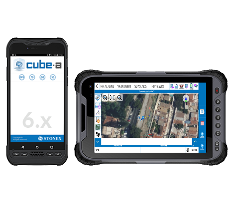
Cube-a Software TS | GPS on board
STONEXOriginal price $500.00 - Original price $630.00Original price List Price:$500.00 - $630.00$500.00 - $630.00Current price $500.00 -
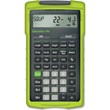
 Original price $58.50 - Original price $58.50Original price List Price:$58.50$58.50 - $58.50Current price $58.50
X-PAD Ultimate Survey Locator
Geomax• Innovative surveying field solution
• Versatile applications for high-end topographic tasks
• Adaptable to survey and construction workflows
• Improved field productivity
• Android
View full detailsOriginal price $58.50 - Original price $58.50Original price List Price:$58.50$58.50 - $58.50Current price $58.50 -
Original price List Price: $710.00You Save: $71.00 -10%Original price $710.00 - Original price $710.00Original price List Price: $710.00Current price $639.00$639.00 - $639.00Current price $639.00
GeoMax Zenith35 Pro GNSS Receiver Upgrade Package
Geomax- Compatible with Zenith35 Pro
Original price List Price: $710.00You Save: $71.00 -10%Original price $710.00 - Original price $710.00Original price List Price: $710.00Current price $639.00$639.00 - $639.00Current price $639.00Save 10% -
Original price List Price: $450.00You Save: $45.00 -10%Original price $450.00 - Original price $450.00Original price List Price: $450.00Current price $405.00$405.00 - $405.00Current price $405.00
GeoMax Zenith35 GNSS Receiver Upgrade Package
Geomax- Compatible with Zenith35
Original price List Price: $450.00You Save: $45.00 -10%Original price $450.00 - Original price $450.00Original price List Price: $450.00Current price $405.00$405.00 - $405.00Current price $405.00Save 10% -
Original price List Price: $490.00You Save: $49.00 -10%Original price $490.00 - Original price $490.00Original price List Price: $490.00Current price $441.00$441.00 - $441.00Current price $441.00
GeoMax Zenith10/20 GNSS Receiver Upgrade Package
Geomax- Compatible with Zenith10/20
Original price List Price: $490.00You Save: $49.00 -10%Original price $490.00 - Original price $490.00Original price List Price: $490.00Current price $441.00$441.00 - $441.00Current price $441.00Save 10% -
Original price List Price: $490.00You Save: $49.00 -10%Original price $490.00 - Original price $490.00Original price List Price: $490.00Current price $441.00$441.00 - $441.00Current price $441.00
GeoMax Zenith25 Pro4 GNSS Receiver Upgrade Package
Geomax- Compatible with Zenith25 Pro4
Original price List Price: $490.00You Save: $49.00 -10%Original price $490.00 - Original price $490.00Original price List Price: $490.00Current price $441.00$441.00 - $441.00Current price $441.00Save 10% -
Original price List Price: $1,290.00You Save: $129.00 -10%Original price $1,290.00 - Original price $1,290.00Original price List Price: $1,290.00Current price $1,161.00$1,161.00 - $1,161.00Current price $1,161.00
GeoMax Zenith16/40 GNSS Receiver Upgrade Package
Geomax- Compatible with Zenith16 and Zenith40
Original price List Price: $1,290.00You Save: $129.00 -10%Original price $1,290.00 - Original price $1,290.00Original price List Price: $1,290.00Current price $1,161.00$1,161.00 - $1,161.00Current price $1,161.00Save 10% -
Original price List Price: $455.00You Save: $45.50 -10%Original price $455.00 - Original price $455.00Original price List Price: $455.00Current price $409.50$409.50 - $409.50Current price $409.50
GeoMax Extended Warranty for Zenith 35 Pro
Geomax- Choice of 1 or 2-year warranty (initial sale only)
- For Zenith 35 Pro
Original price List Price: $455.00You Save: $45.50 -10%Original price $455.00 - Original price $455.00Original price List Price: $455.00Current price $409.50$409.50 - $409.50Current price $409.50Save 10%


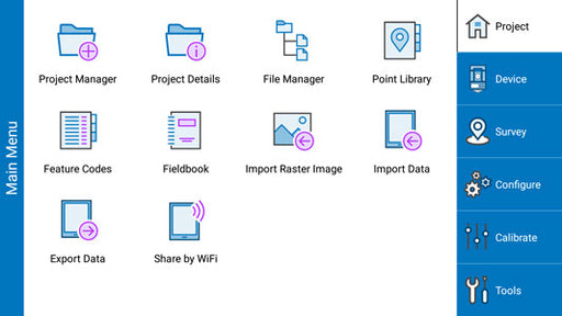
GNSS software is a graphical field solution that offers surveying professionals the ability to manage assets, measure areas, and create maps. Designed to optimize the functionality and control of your GNSS receivers and data collectors, this land surveying software enables you to collect and edit highly-accurate field data, configure GPS antenna height, and switch between different job files. Whether you are an amateur or professional surveyor, its user-friendly interface greatly reduces the learning curve and simplifies setup.
Features of GNSS Software
With advanced data collection and processing features, surveyors can perform additional tasks with their GNSS receivers, such as offset staking, slope staking, cut sheet reports, calculate volumes between two surfaces, and use of optional road templates for road construction projects.
This land surveying software also has a scalable map view that displays points and lines as they are surveyed, offering large-print controls for fast data collection. Background maps and color lines can also be defined.
Office and Land Surveying Software
Field and office go hand in hand when it comes to producing the most accurate survey data. With compatible desktop software, you can process and analyze raw GPS data, export it to CAD, or enhance the accuracy of the collected positions through post-processing. Fast and hassle-free!
Highly accurate land surveying software takes away the burden of complicated functions and offers a step-by-step guide to make sure that you get the job done right! Tiger Supplies offers a variety of GNSS software from recognized brands, such as Ashtech, Spectra, Sokkia, and Topcon.